Being Prepared: Do I Need a GPS for My Boat?
Date Posted: 2 August 2022
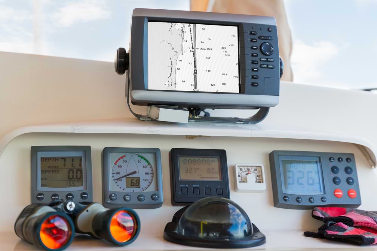
As fun, freeing and relaxing as being on a boat is, it’s important to always keep safety measures in mind and that includes having a marine GPS onboard. In fact, a marine GPS is a crucial element of your emergency equipment. If you venture into rougher areas or decide to take the boat out at nighttime, you’ll need the solid navigational system that a GPS affords. A Handheld GPS can help you navigate and guide you through harbours when you’re returning to a marina. It shows you where you are, and, depending on its features, can even tell you what lies directly beneath your vessel — helping you to avoid grounding on shoals and points. Even if you regularly use your smartphone as a navigational device, this option isn’t quite as reliable as a durable and waterproof marine GPS.
The reality is, most boaters today aren’t super familiar with manual navigational methods. Even experienced boaters don’t necessarily know how to dead reckon with charts and a compass, or utilise a sextant to determine their position. Instead, modern boaters use a marine GPS and chartplotter combo to avoid crashing into reefs and missing channels to harbours. Ultimately, vessels that operate with a GPS and chartplotter have far fewer accidents than those that don’t have electronic navigational systems. While there are many benefits associated with a marine GPS, this is the main reason why you should make sure your vessel is equipped with this tool.
What Features Do You Need in a GPS?
As well as being crucial to the safety of your boat, yourself and your passengers, a GPS can offer several benefits to you.
Chartplotter for Improved Navigation
While some people may use the terms interchangeably, there is a difference between a GPS and a chartplotter. While a GPS tells you your location, a chartplotter can tell you your speed, let you set a destination, and find you the most direct route to that destination with an expected arrival time. Handily, you can often find GPS–chartplotter combos so you can make the most of this incredibly useful feature to plan your journey based on time, daylight, weather conditions and fuel consumption, to name a few without needing another device onboard.
Ability to Save a Location for Future Voyages
GPS plotters have the ability to ‘mark’ a spot and save the associated location so that you can return to said location at a later date. This is especially useful if you find a great place to fish, scuba dive or just kick back.
Anchor Alarm for Improved Safety
If your boat’s anchor slips at night, your marine GPS can alert you and your crew of the issue with enough time to re-anchor it before your boat drifts off.
Security System for Managing Worst-Case Scenarios
If your boat was to get stolen, your GPS would have the ability to provide you with its location, and even set off an alarm if it went out of the specified range. This ability would be a huge help in finding your boat and possibly apprehending the thieves.
Ability to Network to Stay in Contact on the Water & Maximise Convenience
GPS systems can be connected with several other devices, which comes in very handy when you’re out at sea. They can be linked to a depth finder’s sonar, a marine VHF radio, radar units and an auto-pilot for increased safety and convenience. A connection between a marine GPS and an auto-pilot, for example, allows the people on the boat to inform the autopilot of where to steer. Being able to network with VHF radio is also incredibly important, as this connection can be used for DSC (Digital Selective Calling). This means that if you ever have to call the Coast Guard, you can give them your exact position data via the radio transmission.
Fishfinder for Catching the Big One
Some GPS devices also have inbuilt fishfinders, which are game changers for fishing enthusiasts. Fishfinder devices detect reflected pulses of sound energy to find areas teeming with fish to help you get a better day’s haul.
How Does a Marine GPS Vary From a Standard GPS?
A marine GPS is essentially the same as the standard GPS you’d have in your car or on your phone, only waterproof and made for the sea. With a marine GPS, you will be able to pinpoint your location in the ocean and observe it as it moves, just like you would if you were using a GPS on land.
Simple Steps for How to Use a Marine GPS
Using a marine GPS is easy, just follow these easy steps:
- Select your waypoint and hit “Go” to confirm your destination.
- The GPS display screen will show you a series of checkpoints you need to reach to get to your destination. Travel towards these checkpoints and change the direction of the boat as you reach them, making sure your boat’s direction is aligned to the compass.
- Continue until you’ve reached your destination.
- Keep an eye out for obstacles that the GPS might miss.
- Make sure you stay above your boat’s maximum depth. The GPS should give you a warning if you’re heading towards shallow water, but it might miss things like sandbanks and rocks.
With a GPS chartplotter, you simply need to enter the waypoint you want to navigate to by entering the coordinates. Alternatively, if you’re wanting to travel freely before returning to your favourite spot, you need to mark your current location.
Buy Incredible GPS Plotters From Mr Boats!
In Mr Boats’ online store, you can find cheap fishfinders with inbuilt GPS and chartplotter devices. Made for passionate boaters, these products are highly intuitive and durable; perfect for long boating trips under the harsh Australian sun. Get yourself a GPS chartplotter today and make the most of your next voyage!


