


Garmin GPSMAP 67I Rugged Handheld GPS AU/NZ Map with inReach® Satellite Technology Part #: 010-02812-02

Garmin GPSMAP 67 Rugged Handheld Outdoor GPS AU/NZ Map
with inReach® Satellite Technology
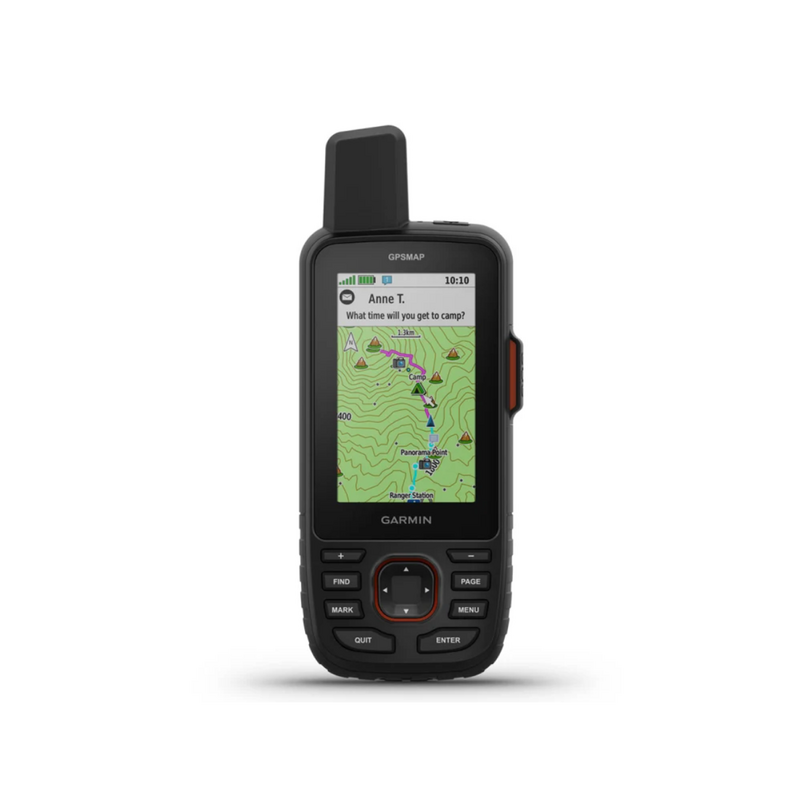
Make more time for adventure with this premium, rugged GPS handheld and satellite communicator. Get inReach® technology that enables two-way messaging, interactive SOS alerts and location sharing1 plus mapping to keep you on course. Access multiple global navigation satellite systems (GPS, Galileo and QZSS). Get access to multiple frequencies sent by navigation satellites for improved position accuracy in areas where GNSS signals are reflected, weak or typically don't penetrate. Navigate every trail with ABC sensors, including an altimeter for elevation data, barometer to monitor weather and 3-axis electronic compass. Download high-resolution photorealistic maps directly to your device via Wi-Fi® technology. Easily find trails, pick stand locations and parking, create waypoints and more. Preloaded maps show you terrain contours, topographic elevations, summits, parks, coastlines, rivers, lakes and geographical points. With an Outdoor Maps+ subscription, you get public land information, landowner names, state plat maps, hunting management unit boundaries, BLM boundaries and more2. Turn on expedition mode, and get up to 425 hours of battery life while using inReach technology. In the default tracking mode, you get up to 165 hours of battery life, and your device will save your location every 10 minutes.
Features:
- Travel longer with up to 165 hours of battery life in tracking mode and up to 425 hours in expedition mode.
- Two-way messaging lets you share the moment with the ones who matter.
- Let your loved ones follow your adventure with location tracking.
- Have an emergency? Trigger an interactive SOS alert anytime, globally.
- Track your position in challenging conditions with multi-band technology and expanded GNSS support.
Specifications:
- Dimesion: 6.2 x 16.3 x 3.5 cm (2.5″ x 6.4″ x 1.4″
- Weigth: 230 g with batteries
- Waterproof: IPX7
- MIL-STD-810: Yes (thermal, shock, water); bare unit onl
- Display Type: Transflective colour TFT
- Display Size: 3.8 x 6.3 cm (1.5″W x 2.5″H ); 7.6 cm diag (3″
- Display Resolution: 240 x 400 pixels
- Battery Type: Rechargeable, internal lithium-io
- Battery Life: Up to 165 hours with inReach® enabled with 10 minute trackin
- Memory/History: 16 GB (user space varies based on included mapping)
- Interface: USB-C
Maps & Memor
- Preloaded Maps: Yes (TopoActive Australia & New Zealand, routable)
- Ability To Add Maps: Yes
- Basemap: Yes
- Automatic Routing (Turn By Turn Routing On Roads) For Outdoor Activities: Yes
- Map Segments: 15,000
- Satellite Imagery: Yes (direct to device)
- Includes Detailed Hydrographic Features (Coastlines, Lake/River Shorelines, Wetlands And Perennial And Seasonal Streams): Yes
- Includes Searchable Points Of Interests (Parks, Campgrounds, Scenic Lookouts And Picnic Sites): Yes
- Displays National, State And Local Parks, Forests, And Wilderness Areas: Yes
- External Memory Storage: Yes (32 GB max microSD™ card)
- Waypoints/Favorites/Locations: 10,000
- Courses: 250, 200 course points per course
- Tracks: 250
- Navigation Track Log: 20,000 points, 250 saved gpx tracks, 300 saved fit activities
- Activities: Yes
- Navigation Routes: 250, 250 points per route; 50 points auto routing
Sensors
- GPS: Yes
- Glonass: Yes
- Galileo: Yes
- QZSS: Yes
- Beidou: Yes
- IRNSS: Yes
- Barometric Altimeter: Yes
- Compass: Yes (Tilt-Compensated 3-Axis)
- High-Sensitivity Receiver: Yes
- Gps Compass (While Moving): Yes
- Multi-Band Frequency: Yes
Daily Smart Features
- Connect Iq™ (Downloadable Watch Faces, Data Fields, Widgets And Apps): Yes
- Smart Notifications On Handheld: Yes
- Weather Forecasts: Yes
- Active Weather : Yes
- Virb® Remote: Yes
- Pairs With Garmin Connect™ Mobile: Yes
Safety and Tracking Feature
- Livetrack: Yes
Tactical Feature
- XERO™ LOCATIONS: Yes
Outdoor Recreation
- Point-To-Point Navigation: Yes
- TracbacK®: Yes
- Area Calculation: Yes
- Fish Forecast: Yes
- Sun And Moon Information: Yes
- Geocaching-Friendly: Yes (Geocache Live)
- Custom Maps Compatible: Yes (500 custom map tiles)
- Picture Viewer: Yes
- LED Beacon Flashlight: Yes
inReach® Features
- Interactive Sos: Yes
- Inreach Weather: Yes
- Send And Receive Text Messages To Sms And Email: Yes
- Send And Receive Text Messages To Other Inreach Device: Yes
- Send And Receive Group Messages: Yes
- Exchange Locations With Other Inreach Device: Yes
- Mapshare Compatible With Tracking: Yes
- Virtual Keyboard For Custom Messaging: Yes
- Send Waypoints To Mapshare During Trip: Yes
- Send Route Selection To Mapshare During Trip: Yes
Outdoor Application
- Compatible With Garmin Messenger App: Yes
- Smart Switching Between Wi-Fi, Mobile And Satellite With Garmin Messenger App: Yes
Connections
- Connections Wireless Connectivity: Yes (Wi-Fi®, Bluetooth®, ANT+®)
What's in the Box :
- GPSMAP 67i
- Type A to Type C USB cable
- Carabiner clip
- Documentation
| SKU | 010-02812-02 |
| Model # | 010-02812-02 |
| Barcode # | 76375930865 |
| Brand | Garmin |
| Artist / Author | Garmin GPSMAP 67I Rugged Handheld GPS AU/NZ Map with inReach® Satellite Technology Part #: 010-02812-02 |
| Shipping Weight | 2.0000kg |
| Shipping Width | 0.062m |
| Shipping Height | 0.035m |
| Shipping Length | 0.163m |
| Shipping Cubic | 0.000353710m3 |
| Type | Garmin GPSMAP 67I Rugged Handheld GPS AU/NZ Map with inReach® Satellite Technology Part #: 010-02812 |
| Format | Garmin GPSMAP 67I Rugged Handheld GPS AU/NZ Map with inReach® Satellite Technology Part #: 010-02812-02 |
Be The First To Review This Product!
Help other Mr Boats users shop smarter by writing reviews for products you have purchased.


