


Lowrance HDS 9 Pro Sounder / GPS Chartplotter with Active Imaging HD 3-in-1 Transducer - P/N 000-15983-001
Lowrance HDS 9 Pro Fishfinder Chartplotter + Transducer

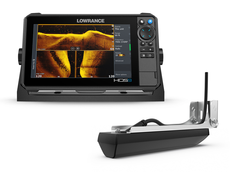
Lowrance HDS PRO 9 Fishfinder/Chartplotter
See more and catch more with the new HDS PRO, giving you the clearest and most-detailed views with new, higher-resolution ActiveTarget® 2 Live Sonar and new, ultra high-definition ActiveImaging™ HD.
Our clearest sonar ever, Active Imaging HD delivers high-definition views of Lowrance CHIRP sonar, SideScan and DownScan Imaging™. FishReveal™ has also been expanded to be available on SideScan* and DownScan, making fish easier to identify to the sides and beneath the boat. (*Requires S3100 Module)
ActiveTarget 2 Live Sonar provides wider, higher-resolution views of fish movement and structure. It also supports plug-and-play installation of two ActiveTarget transducers, making it possible to watch multiple views simultaneously, and to widen Front and Scout modes for better bait tracking.
The ultimate clarity
The better your view, the better your fishing. From the high-definition touchscreen display to the high-level clarity of the newly-enhanced Lowrance sonar, HDS Pro delivers a full range of meaningful underwater views that will take your fishing experience from good to great.
The SolarMAX™ HD touchscreen provides stunning images of fish, structure and chart details that are easy to see from any angle, in direct sunlight and through polarized lenses – a real difference maker on the water. See unmatched clarity on-screen with Lowrance’s superior, high-resolution Active Imaging™ HD sonar and ActiveTarget® 2 Live Sonar technologies.
All the chart details – preloaded
Find great fishing spots with Enhanced Embedded charts for New Zealand and Australia. Spend more time catching fish and less time finding them, thanks to the detail of C-MAP inland and coastal charts built into HDS Pro displays. Enhanced Embedded charts help you find ledges, drop-offs, and ditches – then they help you navigate there with precision.
Complete bow to stern boat control
HDS PRO gives you full bow-to-stern networking and control of the Ultimate Fishing System.
With HDS PRO at the heart of your fishing system, it’s easy to customize your boat to fit the way you fish with your choice of fish-finding, navigation, network and entertainment options. HDS PRO offers support for the complete range of top fish-finding technologies – from ActiveTarget® 2 Live Sonar and Active Imaging™ HD to touchscreen control of Power-Pole® Anchors, Ghost® Trolling Motor and more.
Expand your system – taking advantage of radar, autopilot and NMEA 2000® compatibility – and add SiriusXM® Weather/Audio to monitor changing weather conditions and to listen to your favorite tunes
Features:
- SolarMAX™ HD Touchscreen viewable at extreme angles and through polarized lenses
- New! High-definition up to 1.2MHz Active Imaging™ HD ready (Lowrance CHIRP/SideScan/DownScan Imaging™)
- New! High-resolution ActiveTarget® 2 Live Sonar ready
- FishReveal™ with new SideScan view, as well as Downscan*
- Available in 9, 10, 12 and 16-inch display size
- Preloaded C-MAP® Enhanced charts for New Zealand and Australia
- Real-time mapping available with C-MAP® Genesis Live.
- Support for new ActiveTarget® Scout and Ghost® Trolling Motor 360 chart overlay views
- Large programmable keys for 10, 12 and 16-inch sizes
- Touchscreen control of Power-Pole® anchors, Ghost® Trolling Motor, Autopilot and Lowrance Outboard Pilot
- NMEA 2000®, Wireless and Bluetooth®, connectivity – plus smartphone notifications
- Wide range of optional chart upgrades including C-MAP® REVEAL, Navionics®, Florida Marine Tracks and more.
*SidescanFishReveal requires S3100 module and a compatible transducer
Specifications:
Autopilot
Manouevres / Turn Patterns: Course Heading Waypoint Power Steer U-Turn C-Turn SpiralZ igzag Square Lazy-S
Steering Modes: Course Heading Waypoint Power Steer
Connectivity
NMEA 0183 Sentences supported: TX / RX - GPS Receive GGA GLL GSA GSV VTG ZDA Transmit GGA GLL GSA GSV VTG ZDA GLCTX / RX - Navigation Receive RMC Transmit AAM APB BOD BWC BWR RMC RMB XTE XDRTX / RX - Sonar Receive DBT DPT MTW VLW VHM Transmit DBT DPT MTW VLW VHMTX / RX - Compass Receive HDG HDT HDM Transmit HDGTX / RX - Wind Receive MWV MWD Transmit MWV MWDTX / RX - AIS / DSC* Receive DSC DSE VDM* AIS sentences are not bridged to or from NMEA 2000.
Bluetooth: Integrated Bluetooth 4.0 with support for Bluetooth Classic
Ethernet: 1x 100 Mbit, 6 max MFD's on a network
N2K PGNs: Receive only 65240 ISO Commanded Address, 127245 Rudder, 127251 Rate of Turn, 127257 Attitude, 127488 Engine Parameters, Rapid Update, 127489 Engine Parameters, Dynamic, 127493 Transmission Parameters, Dynamic, 127505 Fluid Level, 127508 Battery Status, 129033 Time and Date, 129038 AIS Class A Position Report, 129039 AIS Class B Position Report, 129040 AIS Class B Extended Position Report, 129794 AIS Class A Static and Voyage Related Data, 129801 AIS Address Safety Related Message, 129802 AIS Safety Related Broadcast Message, 129808 DSC Call Information, 130313 Humidity, 130314 Actual Pressure, 130576 Small Craft Status, 65285 Temperature with Instance, 65325 Reprogramming Status, 65480 Parameter Reply, 130817 Product Information, 130820 Reprogramming Status, 130832 Fuel Used – High Resolution, 130834 Engine and Tank Configuration, 130838 Fluid Level Warning, 130842 AIS and VHF Message Transport, 130843 Sonar Status – Frequency and DSP VoltageTransmit and Receive:59392 ISO Acknowledgement, 59904 ISO Request, 60160 ISO Transport Protocol, Data Transfer, 60416 ISO Transport Protocol, Connection Management, 60928 ISO Address Claim, 126208 NMEA Group Function, 126464 Receive/Transmit PGN’s group function, 126992 System Time, 126996 Product Information, 127237 Heading/Track Control, 127250 Vessel Heading, 127258 Magnetic Variation, 128259 Speed, 128267 Water Depth, 128275 Distance Log, 129025 Position, Rapid Update, 120296 COG and SOG, Rapid Update, 129029 GNSS Position Data, 129283 Cross Track Error, 129284 Navigation Data, 129539 GNSS DOPs, 129540 GNSS Sats In View, 130074 Route and WP Service – WP List - WP Name and Position, 130310 Environmental Parameters, 130311 Environmental Parameters, 130312 Temperature, 130577 Direction Data, 61184 Parameter Command, 65292 Clear Fluid Level Warnings, 65293 LGC-2000 Configuration, 65323 Data User Group Request, 130831 EP-20 Suzuki Engine and EP-50 Storage Device Configuration, 130835 Set Engine and Tank Configuration, 130839 EP-45 Pressure Configuration, 130840 Data User Group Configuration, 130845 Parameter Handle, 130850 Event Command, 130851 Event ReplyTransmit only65287 Temperature Sensor Configuration, 65289 Trim Tab Configuration, 65290 Paddle Wheel Speed Configuration, 130818 Reprogramming Data, 130819 Request Reprogram, 130828 Set Serial Number, 130836 Fluid Level Configuration, 130837 Fuel Flow Turbine Configuration
NMEA 0183: 1x RS422 port Baud rates: 1200, 2400, 4800 (Default), 9600, 19200, 38400, 57600, 115200
NMEA 2000: 1x Micro-C
PC Connectivity: None
Video: Output: No Input: Composite video RCA - single channel via optional adaptor
WiFi: Internal 802.11b/g/n and Compatible with WiFi-1 Module
Display
Backlight Color: Pure White LED
Resolution: 1280 x 720
Screen Brightness: >1200 Nits
Size and Type: 9" (228mm) Solar MAX HD (TM) IPS technology Multi-touch, P-CAP
Viewing Angles: 80° top/bottom, 80° left/right
Electrical
Power Consumption, max: 2.9A @ 13.8VDC with Full Backlight, Sonar on
Power Consumption, min: 2.0A @ 13VDC withwith Full Backlight, Sonar on
Power Consumption, typical: 2.0A @ 13VDC withwith Full Backlight, Sonar on
Recommended Fuse Rating: 3A
Supply Voltage: 12 v DC (10.8-17VDC)
Humidity: IEC 60945 Damp Heat 150°F (66°C) at 95% Relative Humidity (48 hrs)
Environment
Operating Temperature Range: 5°F to 131°F (-15°C to 55°C )
Shock and Vibration: 100,000 cycles of 20 G
Storage Temperature Range: 4°F to 140°F (-20°C to 60°C )
Waterproof rating: IPX7 with card door closed
GPS
Correction: DGPS, WAAS
GPS Receiver Channels: 16
Position Accuracy: 20m RMS
Time to First Fix: 30s
Update rate: 10 Hz
MFD
AIS: AIS Chart and Radar overlay. Target vessel details.
Autopilot: Outboard PilotNAC-1NAC-2Ghost Trolling MotorMotorGuide Xi5/Xi3 Trolling Motor **requires Motorguide PinPoint Gateway
Cartography included: C-MAP AUS/NZ Enhanced Basemap (AUS/NZ models)C-MAP World Background (ROW models)Navionics basemap (AMER and ROW models)
Cartography supported: C-MAP RevealC-MAP DiscoverC-MAP Reveal XC-MAP Discover XC-MAP (MAX N, MAX N+)C-MAP GenesisC-MAP Precision Contour HD (AMER ONLY)Navionics (Gold, NAV+ Platinum+)Insight (Pro and HD)Lowrance Regional Mapping Partners
Digital Switching: C zone Naviop
External Storage: 2 micro SD cards up to 32GB
GPS: 10 Hz GPS / GLONASS WAAS / EGNOS / MSAS
Internal Storage: 8.0 GB Internal
Multimedia: Sonic Hub Sonic Hub 2 Fusion Link products any NMEA 2000 compliant Marine Aduio products
Radar (inc. compatibility): 4G (Broadband) 3G (Broadband) Halo20 / 20+ (Pulse Compression Dome Radar) Halo 24 (Pulse Compression Dome Radar) Halo 3'/4'/6' (Open Array Pulse Compression Radar)
Sonar (inc. compatibility): Integrated: CHIRP Broad band Active Imaging Down Scan Active Imaging Side Scan Active Imaging HD Down Scan Active Imaging HD Side Scan Compatible with: Active Target Active Target 2S3100 Sonar Hub Structure Scan Structure Scan HD Structure Scan 3D Live Sight (requires PSI-1 module)
Waypoints, Routes, Tracks: 3000 Way points 100 Routes 100 Trails with up to 10,000 points per trail
Compass Safe Distance - Metric, imperial: 65 cm (2.1 ft)
Physical
Dimensions (W x H x D): 11.02" (280 mm) x 6.56" (166.7 mm) x 3.06" (77.7 mm)
Mounting Type: Gimbal Bracket Front Dash Flush Mount Rear Dash Flush Mount
Weight: 3.06 lb (1.39 kg)
Other
Warranty Period: 2 Year + 3 additional years of upgrade options Totaling 5 years
Interface: Touchscreen: Full Multi-touch touch screen Keypad:8-way directional keypadZoom +/-Exit Enter Menu Waypoint Power/Light2 - User Programmable Quick Access Keys
Languages: Standard Language Pack: Afrikaans/Afrikaans, Danish/Dansk, German/Deutsch, English (US), English (UK), Spanish/Español, Finnish/Suomi, French/Français, Greek/Ελληνικά, Icelandic/íslenska, Italian/Italiano, Dutch/Nederlands, Norwegian/Norsk, Portugese (Brazil)/Português (BR), Portugese (Portugal)/Português (PT), Swedish/SvenskaAsian Language Pack: English (US), English (UK), Japanese/日本語, Korean/한국어, Thai/ภาษาไทย, Chinese - (simplified) China/简体中文, Chinese - (traditional) Taiwan/繁體中文Eastern European Language Pack:Bulgarian/Български, German/Deutsch, Estonian/Eesti, English (US), English (UK), Spanish/Español, French/Français, Hebrew/ عبری , Croatian/ Hrvatski, Hungarian/ Magyar, Italian/Italiano, Lithuanian/Lietuvos, Latvian/ Latvijas, Polish/Polski, Slovak/ Slovensky, Turkish/TürkçeRussia/Ukraine Language pack: German/Deutsch, English (US), English (UK), Spanish/Español, Italian/Italiano, Russian/Русский, Ukraine/ УкраїнськаMiddle Eastern Language Pack: Arabic (UAE)/ العربية , German/Deutsch, English (US), English (UK), Farsi/ فارسی , French/Français, Italian/Italiano
Packages Includes:
- HDS PRO 9
- Active 3 in 1 Transducer
- Power cable
- Bracket
- Sun / Dust Cover
| SKU | 000-15983-001 |
| Model # | 000-15983-001 |
| Brand | Lowrance |
| Artist / Author | Lowrance HDS 9 Pro Sounder / GPS Chartplotter with Active Imaging HD 3-in-1 Transducer - P/N 000-15983-001 |
| Shipping Weight | 2.0000kg |
| Shipping Width | 0.077m |
| Shipping Height | 0.145m |
| Shipping Length | 0.234m |
| Type | Lowrance HDS 9 Pro Sounder / GPS Chartplotter with Active Imaging HD 3-in-1 Transducer - P/N 000-159 |
| Format | Lowrance HDS 9 Pro Sounder / GPS Chartplotter with Active Imaging HD 3-in-1 Transducer - P/N 000-15983-001 |
Be The First To Review This Product!
Help other Mr Boats users shop smarter by writing reviews for products you have purchased.


